How GPS Knows Exactly Where You Are
You open a map on your phone and, within seconds, a small blue dot appears almost exactly where you’re standing. Start walking and the dot follows you. Get into a car and your phone can tell which road you’re on, how fast you’re moving, when you missed a turn, and where you should go next.
It feels as though your phone must be constantly telling a satellite where you are.
But that’s not actually how GPS works.
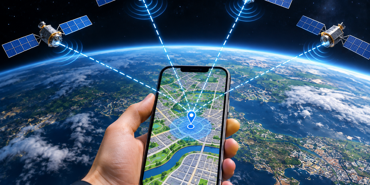
In its basic form, GPS satellites don’t need to know who you are, where you are, or even that your phone exists. They continuously broadcast signals containing extremely precise information about time and their own positions. Your phone listens to several of those signals and uses the tiny differences in their arrival times to calculate where it must be.
In other words, the satellites don’t find you.
Your phone finds itself.
What GPS Actually Means
GPS stands for Global Positioning System. It is a satellite-based navigation system originally developed by the United States and now used around the world.
GPS is one example of a broader category known as Global Navigation Satellite Systems, or GNSS. Other satellite-navigation systems include Europe’s Galileo, China’s BeiDou, and Russia’s GLONASS. Modern smartphones can often receive signals from multiple systems, giving them access to many navigation satellites rather than relying on GPS alone.
The basic principle behind them is similar. Satellites orbit Earth while continuously broadcasting precise timing and positioning information. A receiver—such as the one inside your smartphone—uses those signals to determine its own position.
That sounds simple until you realize just how precise the timing needs to be.
Your Phone Is Basically Measuring Time
At the heart of satellite navigation is an extraordinarily simple idea: if you know how fast something travels and how long it traveled, you can estimate how far away it started.
Radio signals travel at approximately the speed of light.
That’s about 300,000 kilometers per second.
GPS satellites broadcast signals that include precise timing information. Your phone compares when the signal was transmitted with when it was received.
From that tiny time difference, it can estimate the distance between itself and the satellite.
If the signal took longer to arrive, the satellite must be farther away.
If it arrived sooner, the satellite is closer.
The challenge is that light travels so quickly that even extremely small timing errors can translate into significant location errors.
That’s why precise clocks are fundamental to the entire system.
One Satellite Isn’t Enough
Suppose your phone determines that it’s 20,000 kilometers from one satellite.
Does that tell it where you are?
Not really.
Imagine drawing an enormous sphere around the satellite with a radius of 20,000 kilometers.
You could theoretically be anywhere on that sphere.
Now your phone receives a second satellite signal and calculates another distance.
That creates another sphere.
The places where those two spheres intersect narrow the possibilities considerably.
Add another satellite and the possible location becomes narrower again.
With enough independent distance measurements, the receiver can calculate a specific position.
This process is commonly explained using the concept of trilateration.
Trilateration Isn’t the Same as Triangulation
People often say GPS uses triangulation.
Technically, that’s not the best description.
Triangulation determines a location using angles.
GPS primarily determines position by measuring distances from satellites.
That’s trilateration.
Imagine standing somewhere in a city without knowing where you are.
Someone tells you that you’re exactly two kilometers from the train station. That doesn’t identify your location because you could be anywhere along a circle around the station.
Then someone tells you that you’re one kilometer from the museum.
Now the possibilities become much narrower.
Add your distance from another known landmark and you can identify your position.
GPS uses a three-dimensional version of this idea with satellites instead of landmarks.
Why GPS Usually Needs at Least Four Satellites
You might assume three satellites should be enough to determine a three-dimensional position.
In an ideal mathematical world with a perfectly synchronized receiver clock, that could work.
Your smartphone, however, doesn’t contain the same extraordinarily precise atomic clocks used aboard navigation satellites.
That creates another unknown: the error in your phone’s clock.
A fourth satellite provides additional information that allows the receiver to solve for both its three-dimensional position and its clock offset.
That’s why GPS positioning generally relies on signals from at least four satellites.
In practice, your phone may use many more.
More satellite measurements can improve reliability and help the system deal with imperfect conditions.
The Satellites Have Extremely Accurate Clocks
Navigation satellites carry atomic clocks.
These clocks are extraordinarily precise because tiny timing errors can create large positioning errors.
Consider how quickly radio signals travel. Light covers roughly 300 meters in one millionth of a second.
So an error of only a tiny fraction of a second can shift the calculated distance significantly.
The entire positioning system therefore depends on precise timing.
The satellites continuously broadcast timing information, while ground systems monitor the constellation and help maintain accurate orbital and clock data.
Your phone doesn’t need an atomic clock of its own because the positioning calculations can estimate and correct its clock error using signals from multiple satellites.
How Does Your Phone Know Where the Satellites Are?
Knowing how far away a satellite is isn’t useful unless the receiver also knows where that satellite was when the signal was transmitted.
GPS signals therefore contain information describing satellite positions and orbital data.
Your receiver uses this information to determine where each satellite should be.
It then combines the satellite’s known position with the estimated distance from that satellite.
Repeat the process across several satellites, and the phone can solve for its own position.
So your location depends on two essential pieces of information from each satellite: where the satellite is and when its signal left.
The Satellites Are Very Far Away
GPS satellites orbit thousands of kilometers above Earth.
That distance is important because it allows individual satellites to cover enormous portions of the planet.
A constellation of satellites is arranged so that receivers in most open areas can see several satellites at once.
Your phone doesn’t literally “see” them with a camera.
Its antenna receives radio signals transmitted from the satellites.
The more useful satellite signals available, the better the receiver’s chances of calculating a reliable position.
This is why GPS generally works extremely well outdoors with a clear view of the sky.
Why GPS Can Struggle Indoors
Satellite signals reaching Earth are relatively weak.
They’ve traveled thousands of kilometers through space before reaching your tiny smartphone antenna.
Roofs, walls, metal structures, underground spaces, and other obstacles can weaken or block them.
That’s why GPS performance often becomes worse inside large buildings, underground parking garages, tunnels, and subway systems.
Your phone may still show a location, but that doesn’t necessarily mean GPS itself is working perfectly.
Modern phones combine several positioning technologies.
When satellite signals are weak, information from Wi-Fi networks, cellular infrastructure, and sensors can help estimate where you are.
Why GPS Gets Confused Between Tall Buildings
Dense cities create another problem.
Radio signals can bounce off buildings before reaching your phone.
This is known as multipath propagation.
Imagine a satellite signal traveling toward your phone but reflecting from the side of a skyscraper before arriving.
The signal traveled farther than a direct path would have.
Because GPS estimates distance using travel time, that additional distance can introduce errors.
This is one reason your blue dot might jump to the opposite side of a street or temporarily place you inside a building in a dense urban area.
Modern receivers and positioning algorithms attempt to recognize and reduce these errors, but difficult environments remain challenging.
Your Phone Doesn’t Rely on GPS Alone
The blue dot on your smartphone map is often the result of several technologies working together.
Satellite navigation provides highly useful absolute positioning.
Wi-Fi can help determine location based on nearby wireless networks.
Cellular information can provide another estimate based on network infrastructure.
Accelerometers measure changes in motion.
Gyroscopes measure rotation.
Magnetometers can contribute compass information.
Barometers can sometimes help estimate changes in elevation.
Your phone can combine these signals to produce a more stable location estimate.
This process is often called sensor fusion.
Instead of trusting one source completely, the device combines several imperfect sources to create a better result.
How Wi-Fi Helps Find Your Location
Your phone can sometimes determine its approximate location even when satellite reception is poor by observing nearby Wi-Fi networks.
Large location databases can associate Wi-Fi access points with geographic locations.
Your phone doesn’t necessarily need to connect to those networks.
The presence and signal characteristics of nearby access points can provide useful clues about where the device is.
If several known Wi-Fi networks are visible, the phone may be able to estimate its position surprisingly well.
This is particularly useful indoors and in dense urban areas where satellite signals may be obstructed.
It also explains why location services can sometimes work even when GPS reception is poor.
How Cellular Networks Help
Cellular infrastructure can provide another location signal.
Your phone is constantly communicating with cellular network equipment while connected to mobile service.
Information about nearby cell sites can provide a rough geographic estimate.
Depending on the network and available measurements, more sophisticated positioning techniques can improve that estimate.
Cellular positioning generally isn’t a direct replacement for high-quality satellite positioning, but it can help your phone determine approximately where it is while waiting for better information.
It can also help the device obtain satellite positioning more quickly.
Why GPS Sometimes Takes Longer to Start
A satellite-navigation receiver needs several pieces of information before it can calculate an accurate position.
If the device hasn’t used satellite positioning for some time, it may need to obtain updated information about available satellites and their orbits.
That can take time if the receiver has to gather everything directly from satellite signals.
Smartphones often use assisted GPS, commonly called A-GPS, to speed up this process.
Information from internet or cellular services can help the phone determine which satellites it should look for and provide useful supporting data.
Instead of beginning completely blind, the receiver starts with clues.
That’s one reason smartphones can often establish a location very quickly.
How Your Phone Knows Which Direction You’re Facing
Knowing your location and knowing your direction are different problems.
If you’re standing still, GPS can tell your phone approximately where you are, but determining which way you’re facing can require additional sensors.
A magnetometer functions somewhat like a digital compass by detecting Earth’s magnetic field.
A gyroscope measures rotational movement.
An accelerometer measures acceleration.
The phone combines information from these sensors to estimate its orientation.
That’s why the arrow on a navigation app can rotate when you turn the phone, even if you haven’t moved several meters.
Once you’re moving, changes in your GPS position can also help determine your direction of travel.
How GPS Calculates Your Speed
GPS doesn’t need to look at your car’s speedometer to know how quickly you’re traveling.
If your location changes over time, the system can estimate speed from that movement.
Satellite-navigation receivers can also use characteristics of the radio signals themselves to make very precise velocity estimates.
That’s why navigation apps can often display your speed while you’re driving, cycling, running, or walking.
Again, the phone is using measurements and timing rather than asking the road or vehicle how fast you’re moving.
Why Maps Sometimes Put You Exactly on the Road
GPS accuracy isn’t always precise enough to identify exactly which part of a road you’re occupying.
Yet navigation apps often appear to keep your position perfectly attached to the road.
Part of that comes from software.
If your calculated position is slightly beside a road but your movement, direction, and route all strongly suggest you’re driving on that road, navigation software can infer the most likely location.
This is sometimes called map matching.
The application combines positioning information with knowledge of the road network.
If you’re traveling at 80 kilometers per hour parallel to a highway, it’s much more likely that you’re driving on the highway than moving through the field five meters beside it.
The map can therefore present a corrected, more useful position.
Why Your Location Is Shown as a Circle
You’ve probably noticed that map applications sometimes show a blue dot surrounded by a larger translucent circle.
That circle represents uncertainty.
Positioning systems don’t usually know your location with infinite precision.
Instead, they calculate an estimate with some expected range of error.
If satellite reception is excellent and several strong signals are available, the uncertainty may be small.
If you’re indoors or surrounded by tall buildings, the circle may become much larger.
The phone is effectively saying:
“I’m fairly confident you’re somewhere around here, but I can’t determine the exact point.”
That’s a much more accurate way to think about digital location than imagining GPS always knows your position down to the centimeter.
Is GPS Accurate to the Exact Centimeter?
Ordinary smartphone GPS generally isn’t.
Under good conditions, consumer devices can often determine position within several meters, although performance varies considerably depending on hardware, environment, satellite visibility, atmospheric conditions, and the positioning technologies being used.
Specialized equipment can achieve much greater precision.
Surveyors, researchers, agriculture systems, construction equipment, and other professional applications can use advanced techniques and correction services to reduce positioning errors dramatically.
Some systems can achieve centimeter-level accuracy under suitable conditions.
But the location dot on an ordinary smartphone map shouldn’t automatically be interpreted as your exact physical position.
It’s an estimate.
A very impressive estimate, but still an estimate.
The Atmosphere Can Affect GPS Signals
Satellite signals don’t travel through a perfect vacuum all the way to your phone.
They pass through Earth’s atmosphere.
Different atmospheric layers can slightly alter how radio signals travel.
Because satellite navigation depends on extremely precise timing, even small delays matter.
GPS systems use models and multiple signal techniques to compensate for these effects.
Professional correction systems can improve accuracy further by measuring errors and providing additional information to receivers.
This is another reminder of how remarkable GPS actually is.
The system is calculating your position from signals sent by objects moving thousands of kilometers above you while accounting for tiny timing errors and environmental effects.
Einstein Is Quietly Involved Too
GPS is one of the most famous everyday technologies in which Einstein’s theories of relativity have practical consequences.
Satellite clocks experience time differently from clocks on Earth’s surface because of their speed and the difference in gravitational conditions.
The effects are tiny from a human perspective.
For GPS, tiny matters.
If engineers ignored relativistic effects, clock errors would accumulate and positioning accuracy would deteriorate significantly.
The system therefore accounts for those effects.
So every time you use satellite navigation to find a café, relativity is quietly helping you get there.
Does GPS Require the Internet?
Basic GPS positioning doesn’t require an internet connection.
A GPS receiver can determine its location using satellite signals without downloading a map from the internet.
That’s why dedicated navigation devices can work in places without mobile coverage.
However, the apps on your phone often need internet connectivity for other reasons.
They may download maps, retrieve traffic information, search for businesses, calculate cloud-based routes, or obtain assisted-positioning data.
If you download offline maps in advance, your phone can still perform many navigation functions without an active internet connection.
GPS tells the device where it is.
The map tells you what’s there.
Those are separate systems.
Does GPS Use Mobile Data?
Receiving basic GPS satellite signals doesn’t consume your mobile data allowance.
The satellites are broadcasting radio signals, and your phone is simply listening.
However, the navigation application may use mobile data to download map tiles, traffic conditions, business information, route changes, and other online content.
That’s why using navigation can consume some data even though GPS itself doesn’t depend on a mobile-data connection.
The distinction is similar to a radio.
Listening to the broadcast and downloading additional information from the internet are two different things.
Can Satellites Track Your Phone Through GPS?
Basic GPS is fundamentally a one-way broadcast system.
GPS satellites transmit signals.
Your phone receives them.
Your phone doesn’t need to transmit its identity or location back to the GPS satellites in order to calculate its position.
That means the GPS constellation itself isn’t following your blue dot around the map.
However, your phone can share the location it calculates with applications, operating-system services, websites, mobile networks, emergency services, or other people depending on permissions, settings, and circumstances.
That’s a separate process.
The satellite system helps your phone determine where it is.
What happens to that location information afterward depends on the device, applications, services, and permissions involved.
Why Location Permissions Matter
Because smartphones can determine location so effectively, location data can be extremely sensitive.
Knowing where someone is can reveal where they live, work, shop, travel, exercise, and spend time.
Modern mobile operating systems therefore provide permission controls for location access.
An application might be allowed to access your location only while you’re using it, always, once, or not at all, depending on the platform and settings.
Some systems can also provide an approximate location instead of a precise one.
It’s worth reviewing these permissions occasionally.
A navigation app obviously has a strong reason to know your location.
A calculator probably doesn’t.
GPS Is Really a Clock System Disguised as a Map Feature
When most people think about GPS, they think about maps.
But GPS itself doesn’t contain the restaurant names, streets, traffic conditions, or colorful navigation interface you see on your phone.
At its core, GPS is largely a system built around extraordinarily precise timing and known satellite positions.
The satellites broadcast.
Your receiver listens.
It measures how long signals took to arrive.
It calculates distances.
It combines several measurements.
And from those measurements, it determines where it must be.
Everything else—the map, route, destination search, traffic information, estimated arrival time—is another layer built on top.
The Simple Version
GPS doesn’t work because a satellite looks down and finds your phone.
It works because satellites continuously broadcast precisely timed radio signals along with information about where they are.
Your phone receives signals from several satellites and measures how long those signals took to arrive.
Because radio signals travel at a known speed, your phone can estimate how far away each satellite is.
One satellite gives it a huge range of possible locations.
Additional satellites narrow those possibilities.
With signals from at least four satellites, the receiver can calculate its three-dimensional position while also correcting for the error in its own clock.
Your smartphone can then combine that result with Wi-Fi networks, cellular information, motion sensors, compass data, maps, and other technologies to produce the familiar blue dot.
So when your phone tells you where you are, the satellites aren’t watching you.
They’re essentially broadcasting:
“I was here at exactly this time.”
Your phone listens to several of them and works out the rest.
And it does all of that quickly enough that you can miss a turn, glance at your screen, and hear “rerouting” almost immediately.